I've had questions about Iceland from people interested in going. I've been twice: in June 2015, and in March 2017. I've written up the 2015 trip (click here) but not the 2017 trip; and the earlier report was perhaps more information than people want. So what follows is a quick overview of interesting things to do, either solo or as part of an organised multi-day hiking tour.
Note that most place names can be found using Google Maps.
Multi-day supported hikes
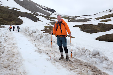
These get you away from roads and towns, with a range of levels of support. The tour organiser hopefully will have taken advantage of the excellent network of cabins, which include a large common cooking and eating area on the ground floor and separate sleeping platforms for men and women upstairs. There will usually be a latrine and a coin-operated, propane-powered shower (get undressed before putting in your coin, because the meter starts ticking immediately...).
The tour I took with a friend in 2015 was organised by Fjallabak (click here). They have a selection of tours; I opted for the eastern inlets (click here) through the homes of the Elves, an hour's flight from Reykjavik. The company is run by the daughter of the founders and is completely Icelandic, so your payments go entirely to locals. National Geographic recommended this trip and it is indeed superb. There were 8 of us (2 Canadians, three Swiss ladies, and three Americans), plus the guide.
A typical day was 10 to 15 km and perhaps 400 to 500 vertical metres as we crossed over the headland or col separating one fjord from the next; at least one mountain stream had to be forded on foot so you will want water shoes to keep your hiking boots dry. Your day pack needs to include cold and wet weather gear even in summer, but the tour includes a 4wd vehicle to carry your bigger bag (sleeping bag & dry clothes) as well as food from cabin to cabin, and serves to evacuate anyone who feels it is too much. Pictures follow; there are other tour organisers offering a similar range of outings. Closer to Reykjavik you will find lots of tours of the Mount Hekla and Landmannalaugar area, and these may be more heavily travelled than the more remote eastern trip I took.
 |
Icelandic ponies are related to Mongol ponies. You can find horseback rides as well.
|
 |
Typical descent into a fjord.
|
 |
| A guide with a GPS and personal knowledge of the area is a good idea as the descent from the col into the next valley can be unclear; there are after all no trees to which trail markers can be attached. Be prepared for snow, rain and fog. Trail markers consist of stones or sticks which can be hidden in snow even at the end of June. |
|
 |
We were the first group on this route in late June 2015 and the authorities thoughtfully plowed some of the routes over the cols ahead of us, not just for us but for the 4X4 truck with our gear and food. Some trails were narrower and steeper, but the group included a couple of people who found this challenging, so I suspect the guide made an on-the-spot-decision to opt for easier trails or 4x4 tracks as we got further into it.
|
 |
| Typical cabin. Reservations are needed for the sleeping accommodations, but if you hike in with your tent, you can set up pretty much anywhere. (Likely a park pass of some kind is also needed). | |
|
 |
| One of my favourite pictures, heading into Loðmundarfjörður. At left you can just see the weekly ferry from Seyðisfjörður heading out to Denmark via the Faroes. |
Solo or self-directed tours and day hikes
South coast
After the 2015 organised tour, I set out alone in a rental car along the south coast. There are plenty of spots to get out and stretch your legs, such as the volcanic ash beach just east of the town of Vik where I rented a room. This is where the iconic picture of three spires comes from; the spot turns up in Icelandic tourist brochures.
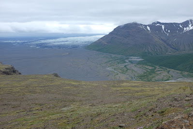
A more strenuous day hike can be found further east along the south coast, in
the heart of
Europe’s largest national park, Vatnajökulsþjóðgarður. I hiked Skaftafellsheiði,
the mountain next to Skaftafellsjökull. It’s a 17 km loop, 700 meter
vertical gain, promising views over the Skaftafellsjökull glacier. This is a tongue
off Vatnajoküll, the towering slab of ice visible from the highway that
is Europe’s largest glacier. (Incidentally the ending 'jökull', pronounced something like 'icicle', means 'glacier'.) The park includes a range of other hikes and can be found online.
 |
An excellent hike on well marked trails up Skaftafellsheiði.
|
Also along this stretch are a variety of glacial lagoons, some with parking lots just off the highway, others a bit further in. The easily accessed ones are, as always, the busiest and I couldn't get into the parking lot at Jökulsárlón.
 |
People on the shoreline give a nice sense of scale.
|
Westman Islands (Vestmannaeyjar) and Heimaey
These islands are accessible by ferry from the South coast, or by a short flight from Reykjavik Municipal airport (not Keflavik). As the winds blow like the dickens here, the landing can be entertaining if you choose the flight... There are lots of self-directed walks around the town of Heimaey, and a guided bus tour. But the winds ... don't drop a piece of paper because it will be halfway to Norway before you can react.
 |
Midnight sun from my hotel in Heimaey.
|
 |
Heimaey, population about 4000, is a fishing port and is the most protected port on the south coast.
|
Húsafell and Snæfellsjökull
National Park
To the north and west of Reykjavik is Snæfellsjökull
National Park and Húsafell, which I visited on a return trip in March 2017 on my way to Stockholm. The weather of course was not as good and I didn't get to see much of Snæfellsjökull, which is the volcano Jules Verne used as the starting point for Journey to the Centre of the Earth. But still the scenery is spectacular and there are plenty of opportunities for more or less extensive day hikes, weather permitting.


 |
Any 'highway' beginning with the letter 'F' is for serious and well equipped off-road vehicles only, driven by people who know what they are doing and are familiar with the terrain, as there may be fords and other obstacles along the way. I stayed off them, or only ventured as far as seemed reasonable with my little Nissan 4wd before turning back; get stuck up here in a rental and you are most definitely not covered by the insurance company (the folks at the rental counter at Keflavik warn you about getting water in the engine...)
|
The farm at Húsafell, to the northeast of Reykjavik, gives you access to a glacier tour which is very highly recommended. For tourists arriving in flip flops,
they offer skidoo suits, otherwise your Goretex jacket and pants, with
fleece or down inner layers, will do just fine. (When they found out I
was Canadian, they said oh, OK, no problem, get on the truck.)
 |
The glacier research station is accessed via a decommissioned NATO missile launcher. Just that part was a load of fun.
|
 |
Tire inflation pressures are controlled from the cabin via a cellphone app.
|
 |
Monster truck.
|
 |
| These tunnels need to be redone every year as the glacier shifts and moves. This is Langjokull. |
The hot tub at
Húsafell, heated by volcanic action, was entertaining, with the wind actually whipping up
whitecaps on the surface and sending sleet and ice spray into our faces. I guess you
had to be there.
Still on my bucket list
I hope this has been helpful. I intend to go back as I haven't seen anywhere near all of it, and there isn't a boring moment. Don't miss the Islendingur museum next to Keflavik on your way home.
 |
This ship, the Islendingur ('Icelander'), sailed to New York, via L'Anse aux Meadows, to commemorate 1000 years since Leif Ericsson visited America.
|
